UNESCO Global Geoparks give local people a sense of pride in their region and strengthen their identification with the area. Photo credit: iStock/adiartana
BIMP-EAGA now has three United Nations Educational, Scientific and Cultural Organization (UNESCO) Global Geoparks, a nod to how the sites are being conserved to serve local communities, while highlighting their geological and cultural importance.
Of the 18 new global geoparks that UNESCO named in May, three are in areas in Indonesia and Malaysia covered by BIMP-EAGA. These are the Maros Pangkep UNESCO Global Geopark and the Raja Ampat UNESCO Global Geopark in Indonesia and the Kinabalu UNESCO Global Geopark in Malaysia. The three are the first global geoparks named in BIMP-EAGA.
There are now 195 UNESCO Global Geoparks in 48 countries, covering a total surface area of 486,709 square kilometers, equivalent to twice the size of the United Kingdom.
What are geoparks?
UNESCO Global Geoparks are single, unified geographical areas where sites and landscapes of international geological significance are managed with a holistic concept of protection, education, and sustainable development. The designation was created in 2015.
“By raising awareness of the importance of the area’s geological heritage in history and society today, UNESCO Global Geoparks give local people a sense of pride in their region and strengthen their identification with the area,” said UNESCO.
Geoparks serve local communities by combining the conservation of their geological heritage with public outreach and a sustainable approach to development.
Maros Pangkep
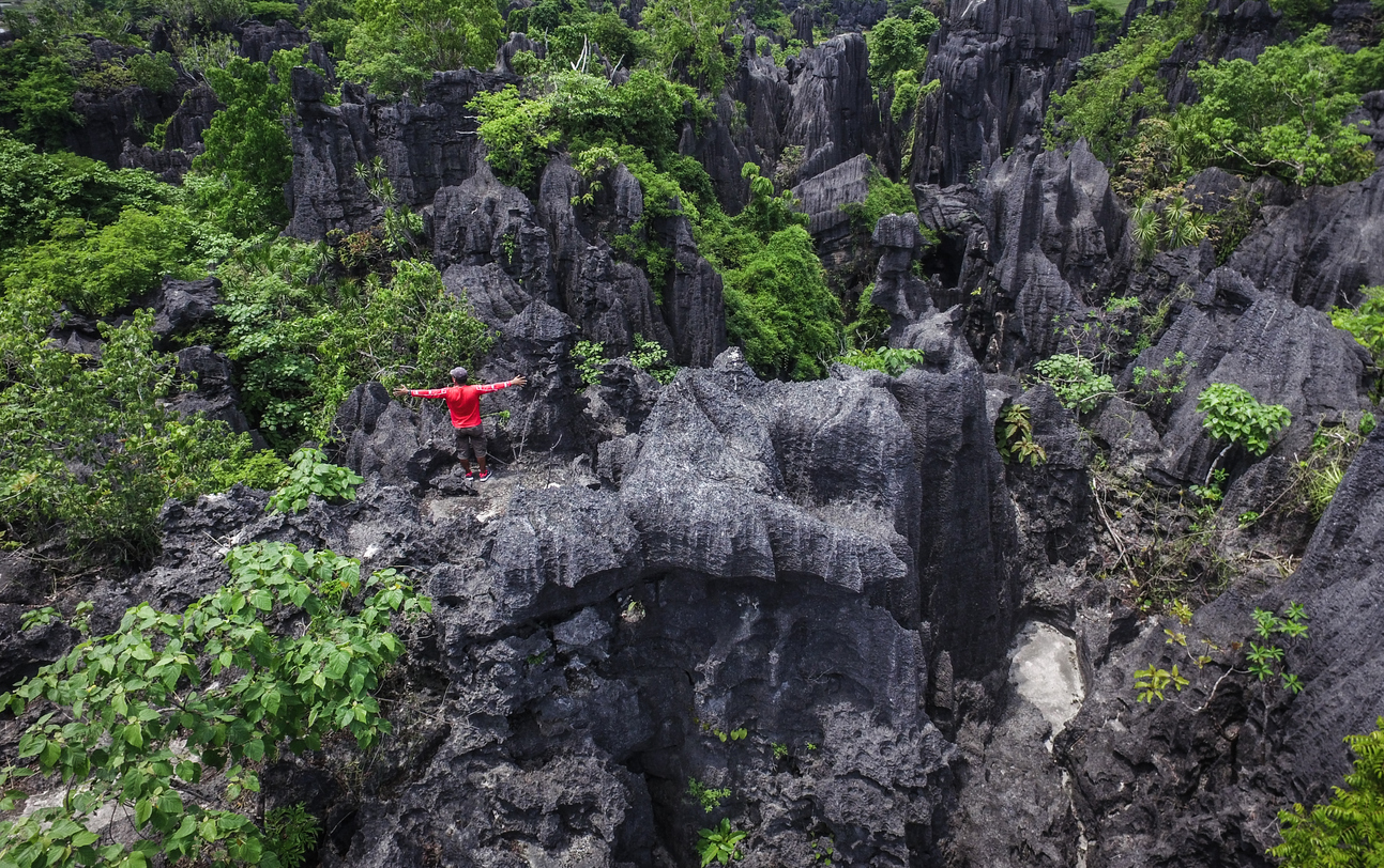
The Maros Pangkep UNESCO Global Geopark is located in South Sulawesi.
UNESCO said the geopark land primarily includes the Bantimurung Bulusaraung National Park on the mainland, the Kapoposang Water Tourism Park, and the Liukang Tupabbiring Local Marine Conservation. It is home to 1,437 species of flora and fauna, including 153 endemic species found only in Sulawesi, as well as 52 protected and endangered species.
One of the primary landforms in the geopark is comprised of metamorphic rocks of low to ultra-high grades, deep marine sedimentary rocks, and tectonic blocks of oceanic crust. This formation dates back 70 million–135 million years and serves as evidence of Sulawesi Island's early evolution, said UNESCO.
The Bugis and Makassarese ethnic groups are predominant in the geopark area. The rich cultural heritage of Bugis civilization in South Sulawesi dates back to the 19th century.
According to the geopark's website, Maros Pangkep's attractions include waterfalls, parks, a traditional village, hot springs, islands, and caves, among others.
In a report from Antara, South Sulawesi Governor Andi Sudirman Sulaiman welcomed the UNESCO designation for Maros Pangkap. "Let us maintain it together as well as a special attraction for tourism in South Sulawesi," he said.
Raja Ampat
The Raja Ampat UNESCO Global Geopark is made up of four primary islands: Waigeo, Batanta, Salawati, and Misool. UNESCO said it is home to the country's oldest rock formation, dating back 443.8 million to 358.9 million years to the Silurian-Devonian era, nearly one-tenth the age of Earth. Prehistoric cave paintings from several thousand years ago were discovered on limestone cliffs and along the coastline, said UNESCO.
The geopark is also known as the "Emerald Karst of the Equator" because of its karst landscapes. It boasts of numerous caves, some below sea level, and is popular among tourists looking for diving destinations.
The geopark's website said it is home to hundreds of unique, rare, and endangered species, as well as various types of endemic animals and plants.
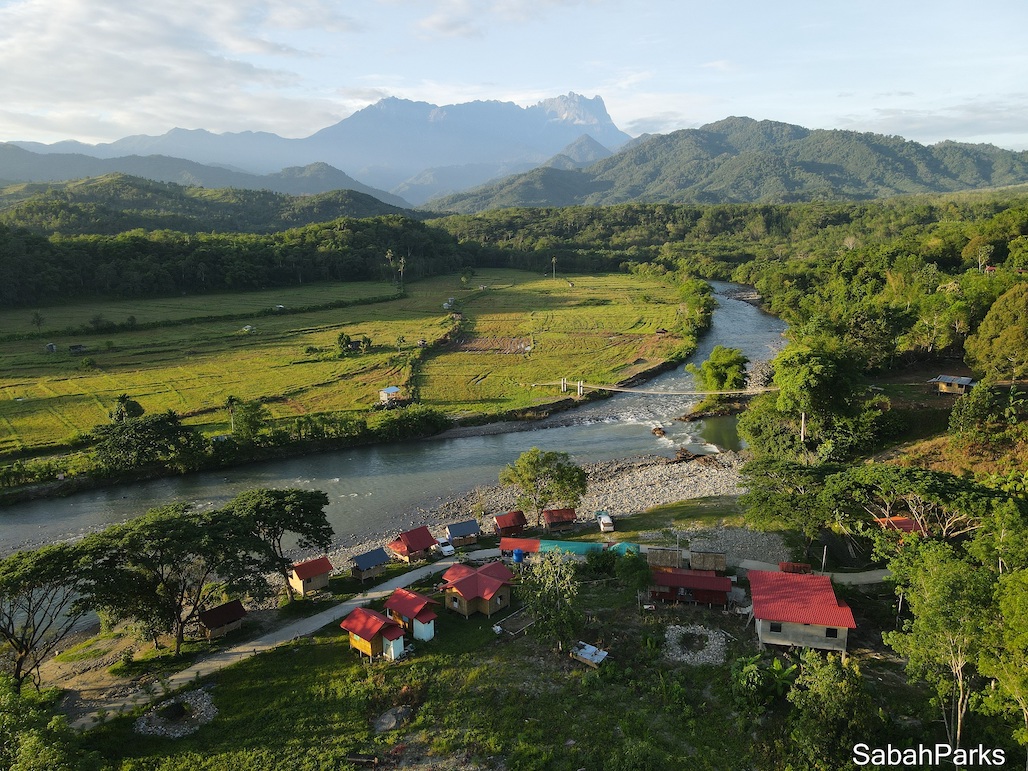
The Kinabalu UNESCO Global Geopark covers 4,750 square kilometers and is home to various flora and fauna. Photo credit: Sabah Parks
Kinabalu
Mount Kinabalu, the tallest peak in Borneo, dominates the Kinabalu UNESCO Global Geopark in Sabah. The geopark covers 4,750 square kilometers and is home to many endemic plants and animals, including 90 orchid species that exist only on Mount Kinabalu and the endemic crimson-headed partridge bird.
UNESCO said the geopark features unique landforms that include the Poring Hot Springs and the Ranau-Tambunan area, which consists of folded and faulted sedimentary rocks. It is a significant site for geological research and education and offers visitors a unique opportunity to explore the geological history of Southeast Asia.
Some 291,300 people live in more than 400 villages inside the geopark. They engage in highland agriculture, animal husbandry, and tourism activities.
According to its website, the geopark is located in the north-western part of Sabah and covers three districts: Kota Belud, Kota Marudu, and part of Ranau.
"This [geopark designation] is a significant achievement for the state government,” Sabah Chief Minister Hajiji Noor was quoted as saying in a media report.
BIMP-EAGA is also home to six UNESCO World Heritage Sites: the Lorentz National Park in Papua, Indonesia; Mt. Kinabalu Park in Sabah, Malaysia; Gunung Mulu National Park in Sarawak, Malaysia; Puerto Princesa Subterranean River and Tubbataha Reefs National Park in Palawan, Philippines; and Mount Hamiguitan Range Wildlife Sanctuary in Mindanao. UNESCO says these sites should be protected because they are “of outstanding value to humanity.”
BIMP-EAGA also boasts of 13 ASEAN Heritage Parks, which are protected areas of high conservation importance to the region. These are: the Tasek Merimbun Heritage Park in Tutong, Brunei Darussalam; the Bantimurung-Bulusaraung National Park and the Wakatobi National Park in Sulawesi; the Lorentz National Park in Papua province; the Gunung Mulu National Park in Sarawak; the Kinabalu National Park in Sabah; the Mt. Apo Natural Park, the Mt. Hamiguitan Range Wildlife Sanctuary, the Mt. Kitanglad Range NaturaI Park, the Mt. Malindang Range Natural Park, the Mts. Timpoong–Hibok-Hibok Natural Monument, and the Agusan Marsh Wildlife Sanctuary in Mindanao; and the Tubbataha Reefs Natural Park in Palawan.